
Lumora intelligence

Built for iPhone and Android

YOUR STATE SEES YOU.

Do you know where?

Introducing

Lumora StateAware

Public surveillance. Documented. Explained. Visible.

StateAware is not publicly released. Current app screens use clearly labelled fictional demonstration records.

Verified development milestone

Phase 2A works on both platforms.

Native development builds have been installed and visually verified with Google Maps on an iPhone simulator and an Android API 36 emulator. This is development evidence, not store approval.

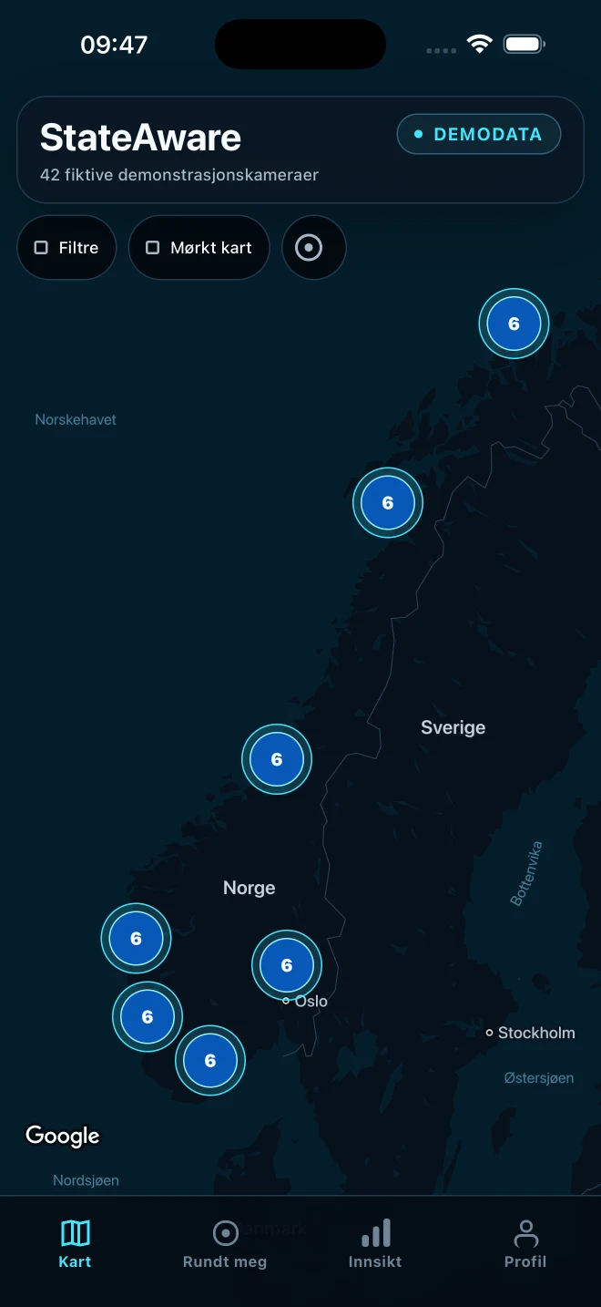
Verified StateAware development build on an iPhone simulator with Google Maps and clearly labelled demo data

Phase 2A

iPhone development build

Google map tiles, attribution, clusters and the StateAware interface were visually verified on an iPhone 17 Pro Max simulator.

Verified development build. The visible camera records are fictional demo data, not live coverage.
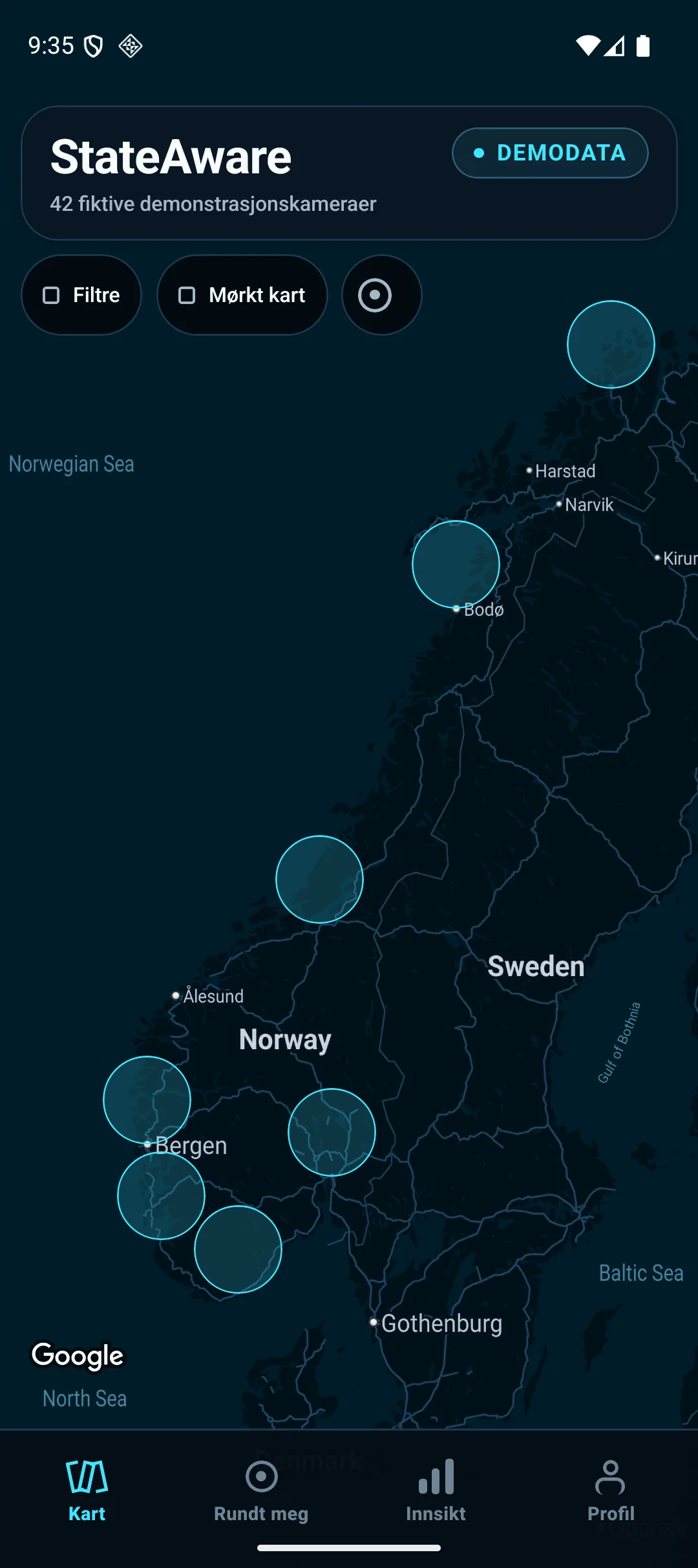
Verified StateAware development build on an Android emulator with Google Maps and clearly labelled demo data

Phase 2A

Android development build

Google map tiles, attribution and the StateAware interface were visually verified on the Lumora API 36 emulator.

Verified development build. The visible camera records are fictional demo data, not live coverage.
01

Shared foundation

One Expo, React Native and TypeScript codebase for iPhone and Android.

02

Core product flow

Map, Around Me, Insights, Profile, filters, clusters and camera detail views.

03

Privacy boundary

Foreground location after user action, kept in memory and processed locally in the established feature.

04

Credential boundary

Separate, platform-restricted development map keys kept out of public Expo configuration.

Still required before release: legally public verified data, production credentials, physical-device testing, signing, store distribution and launch review.

Public space, clearer context

You already pass them.

On the road. In the city. At borders. In tunnels. Around public buildings. Government-controlled cameras are already part of the public spaces around us.

The information may be public. Finding and understanding it is not always easy.

The StateAware map

One map. Clear answers.

StateAware is being built to gather publicly documented information in one understandable map, with the source and verification context kept close to every record.

WHO

Who controls the system?

WHY

What is its documented purpose?

WHAT

What can it record or process?

HOW LONG

How long may information be retained?

StateAware development app showing a dark map and clearly labelled demo data on iPhone
Verified development build. The visible camera records are fictional demo data, not live coverage.

Planned source method

No record without a source.

StateAware does not yet have a live production camera database. The planned data process is designed to keep public evidence, uncertainty and recency visible instead of turning incomplete documentation into certainty.

  1. 01

    Find the public record

    Begin with an official or otherwise legally public, traceable source.

  2. 02

    Separate fact from inference

    Record only what the source supports and keep interpretation clearly labelled.

  3. 03

    Keep unknowns unknown

    Missing documentation stays Unknown — never a confident No.

  4. 04

    Record precision and recency

    Show location precision, source date, access date and last verification.

  5. 05

    Maintain corrections

    Preserve source links and a review trail so records can be updated or withdrawn.

A StateAware record will mean that a source-backed system has been documented. It will never mean that every existing camera is mapped.

Signature analysis

WHAT’S WATCHING HERE?

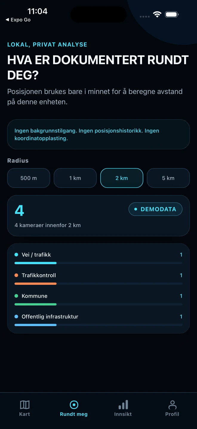
Ask for a local overview when you choose. StateAware calculates nearby context on your device and presents documented categories without turning awareness into alarm.

StateAware Around Me development screen with fictional demo data
Verified development build. The visible camera records are fictional demo data, not live coverage.

Concept example — not live data

47

publicly documented cameras within 2 km

Road and traffic18
Police9
Municipality8
Customs5
Enforcement4
Other public authority3

Public camera view available

Vehicle identifiers processed

Recording information available

Retention information unknown

Source before certainty

A camera location is only the beginning.

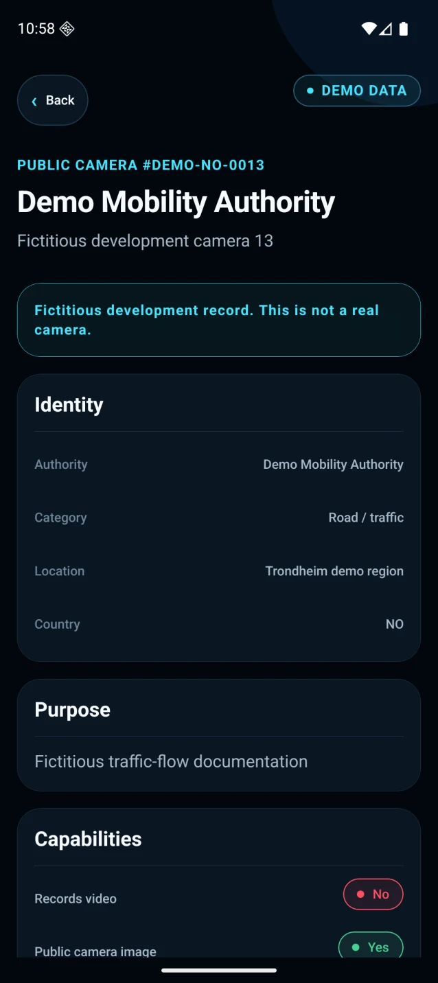
A useful record explains what is documented, when it was verified and what is still unknown. StateAware will never turn missing information into a confident “No.”

AuthorityDocumented public authority
System typeRoad and traffic camera
PurposeTraffic-flow documentation
Public camera imageAvailable where lawful
RecordingUnknown
StorageUnknown
ANPRUnknown
Facial recognitionUnknown
Automated event detectionUnknown
Location precisionApproximate
Official sourceLinked source record
Last verifiedVisible on every record

Unknown means the public documentation does not provide a verified answer.

StateAware camera details on Android with a clearly labelled fictional development record
Verified development build. The visible camera records are fictional demo data, not live coverage.

Place context · planned

See the place. Understand the context.

A later StateAware phase may let you open a documented location in Google Street View when Street View is available.

  • Street View shows Google’s street imagery.
  • The imagery may be older than the StateAware record.
  • It is not the authority’s live camera image.
  • It loads only when you explicitly request it.

Planned later feature — not in the current build

Map intelligence · planned

Documented Surveillance Density

A calm map layer designed to show how closely publicly documented surveillance records appear together.

Low

Moderate

High

Very high

Density describes documentation, not danger, risk or crime.

Documentation quality · planned

How transparent is the system?

The planned Documentation Transparency Score measures how complete the public documentation is, not whether an authority is morally good or bad.

A completeness signal. Never a secret ranking.

01Location and owner
02Purpose and legal basis
03Data processing and retention
04ANPR or documented AI use
05Contact and access information
06Recency of the public source

Privacy by design

We map surveillance. We do not track you.

The current foundation requests foreground location only after a deliberate user action and processes the nearby calculation locally.

Privacy is not about hiding. It is about knowing.

No stored location history

No background tracking

No sale of location data

No advertising tracking

No account required for the basic map

No reporting of live police controls

No routes designed to avoid cameras

Local calculation where practical

Development boundary

What works now. What may come later.

Phase 2A proves a controlled development foundation. Product tiers, prices and release terms have not been approved or announced.

Verified development foundation

Working in Phase 2A

Development evidence — not public availability

  • Google Maps development integration on iOS and Android
  • Map, clusters, filters and camera detail flow
  • Around Me local radius analysis after user action
  • Insights, Profile, Norwegian and English
  • Fictional demo repository separated from the empty release repository
  • Source, precision, recency and tri-state data model

Planned later work

Not released or priced

Roadmap direction only. These items are not an announced product tier or release promise.

  • Legally public, verified production sources
  • Production map configuration and physical-device validation
  • Street View context where available and appropriate
  • Documented surveillance-density layer
  • Documentation Transparency Score
  • Signed App Store and Google Play distribution testing

Trust and boundaries

Not fear. Not avoidance. Awareness.

StateAware is being built as an independent, source-based transparency app for public understanding. It is not affiliated with police, customs, road authorities or any other public authority.

StateAware is

  • Independent and source-based
  • Fact-focused and privacy-oriented
  • Built to make public documentation understandable
  • Clear about confidence, recency and unknowns

StateAware is not

  • A tool for avoiding police or customs
  • A live control-alert service
  • A database of live police positions
  • A map of active covert investigations
  • A guarantee that every existing camera is mapped

StateAware maps publicly documented and verifiable government-controlled surveillance. Some operational or legally protected information is not public and will not be included.

Our ambition is to build a trustworthy, source-based view of publicly documented government-controlled surveillance.

YOUR STATE SEES YOU.

Do you know where?

Lumora StateAware

In development for iPhone and Android.

Apple App Store

Not available yet

Google Play

Not available yet

There is no download, store listing, newsletter or launch signup yet.